How Deep Storms Make Warm Rain
Original SourceTowering thunderstorms, with their anvil-shaped tops stretching into the frigid upper atmosphere at temperatures below -40°C, appear to be nature's ice factories. Looking up at these imposing clouds, most would assume the rainfall they produce must originate from frozen particles. Yet the journey from cloud droplet to raindrop isn't always as straightforward as this intuition suggests.
Writing in Communications Earth & Environment, Ashok Kumar Gupta and colleagues [1] reveal through sophisticated simulations that, contrary to conventional wisdom, deep convective clouds can produce rain predominantly through purely liquid processes. Their findings demonstrate that a critical determining factor is often overlooked: the temperature at the cloud's base.
Precipitation typically forms via two main microphysical routes. The 'warm rain' process involves microscopic cloud droplets, formed on aerosol particles called cloud condensation nuclei (CCN), colliding and coalescing into larger drops heavy enough to fall as rain. This process occurs entirely in the liquid phase. The 'ice crystal' or 'cold rain' process begins when ice crystals form, either on specific aerosol particles known as ice nuclei (IN) or by spontaneous freezing of supercooled droplets at very low temperatures (below about -36°C). These ice crystals can then grow by collecting water vapour or by colliding with supercooled liquid droplets (a process called riming), potentially forming snowflakes or soft hail called graupel. If these ice particles fall below the melting level, they turn into raindrops often referred to as 'cold rain'.
Sensitivity experiments reinforced this conclusion. Artificially warming the cloud base in the colder cases shifted the balance dramatically, with warm-rain contribution increasing to roughly half the total precipitation. The effect was further amplified when combined with reduced aerosol concentrations, which promote larger droplets. Conversely, increasing aerosols in warm-based clouds suppressed warm-rain by producing smaller droplets less prone to collision. The study also revealed how secondary ice production competes with warm-rain processes for available supercooled water.
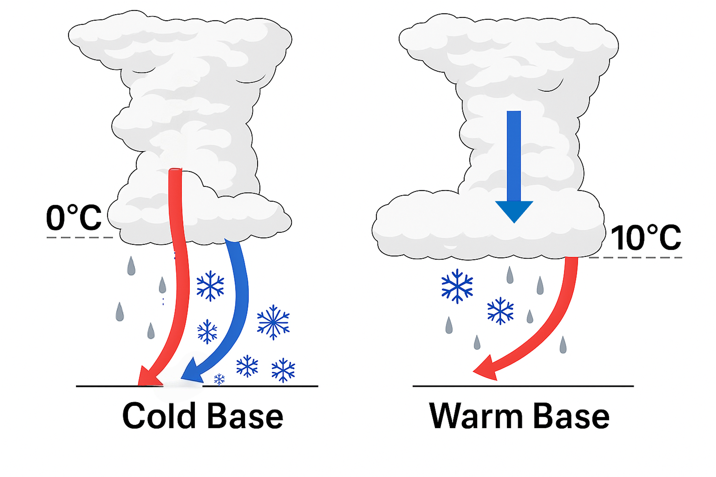 Figure 1: Conceptual illustration of precipitation formation pathways in deep convective clouds with varying cloud base temperatures. In the cold-based cloud (left, 0°C), ice processes dominate precipitation formation (blue arrows), while the warm-based cloud (right, 10°C) shows significantly enhanced warm rain processes (red arrows).
These findings have significant implications. They directly challenge the common assumption that deep convection with ice aloft necessarily implies cold-rain dominance at the surface - an assumption pervasive in satellite observations [3, 4]. Satellites detect ice particles aloft but cannot distinguish between traditional cold-process ice and what might be called "warm graupel" - frozen particles that originated from warm rain processes before being lofted above the freezing level. This misclassification leads to biases in satellite retrievals and large-scale model parameterizations.
The work underscores that the conditions at the cloud base, governed by lower tropospheric temperature and humidity, act as a critical switch controlling precipitation microphysics aloft (Fig 1). This sensitivity suggests that climate change, through warming and alterations in atmospheric moisture and potentially aerosols, could substantially shift the balance between warm and cold precipitation regimes globally, with knock-on effects for water cycles and climate feedbacks. Furthermore, the results emphasize the need for weather and climate models to accurately represent not only ice processes but also warm-rain formation and the crucial intermediate step of raindrop freezing.
While the authors acknowledge limitations inherent to idealized modelling, the consistency across different storm types and sensitivity tests provides confidence in the main conclusion: the origin of rain in deep storms is highly sensitive to the warmth and moisture at their base. Future work could involve implementing similar tracer diagnostics within global climate models to assess these pathway balances on larger scales, alongside targeted observational campaigns designed to better constrain the microphysical processes occurring in the transition zones between warm and cold cloud regions. Gupta and colleagues' work provides a clearer view into the complex life cycle of precipitation, reminding us that even in the coldest reaches of a storm cloud, the rain we feel might have begun its journey simply as colliding water droplets.
References
[1] Gupta, A. K., Deshmukh, A., Waman, D., Patade, S., Jadav, A., Phillips, V. T. J., Bansemer, A., Martins, J. A., & Gonçalves, F. L. T. (2023). The Microphysics of the Warm-Rain and Ice Crystal Processes of Precipitation in Simulated Continental Convective Storms. Communications Earth & Environment, 4(1), 226. https://doi.org/10.1038/s43247-023-00884-5
[2] O'Gorman, P. A. (2015). Precipitation Extremes Under Climate Change. Current Climate Change Reports, 1(2), 49–59. https://doi.org/10.1007/s40641-015-0009-3
[3] Mülmenstädt, J., Sourdeval, O., Delanoë, J., & Quaas, J. (2015). Frequency of Occurrence of Rain from Liquid-, Mixed-, and Ice-phase Clouds Derived from A-Train Satellite Retrievals. Geophysical Research Letters, 42(15), 6502–6509. https://doi.org/10.1002/2015GL064604
[4] Field, P. R., & Heymsfield, A. J. (2015). Importance of Snow to Global Precipitation. Geophysical Research Letters, 42(21), 9512–9520. https://doi.org/10.1002/2015GL065497